An Adventure on the Bottom of the World

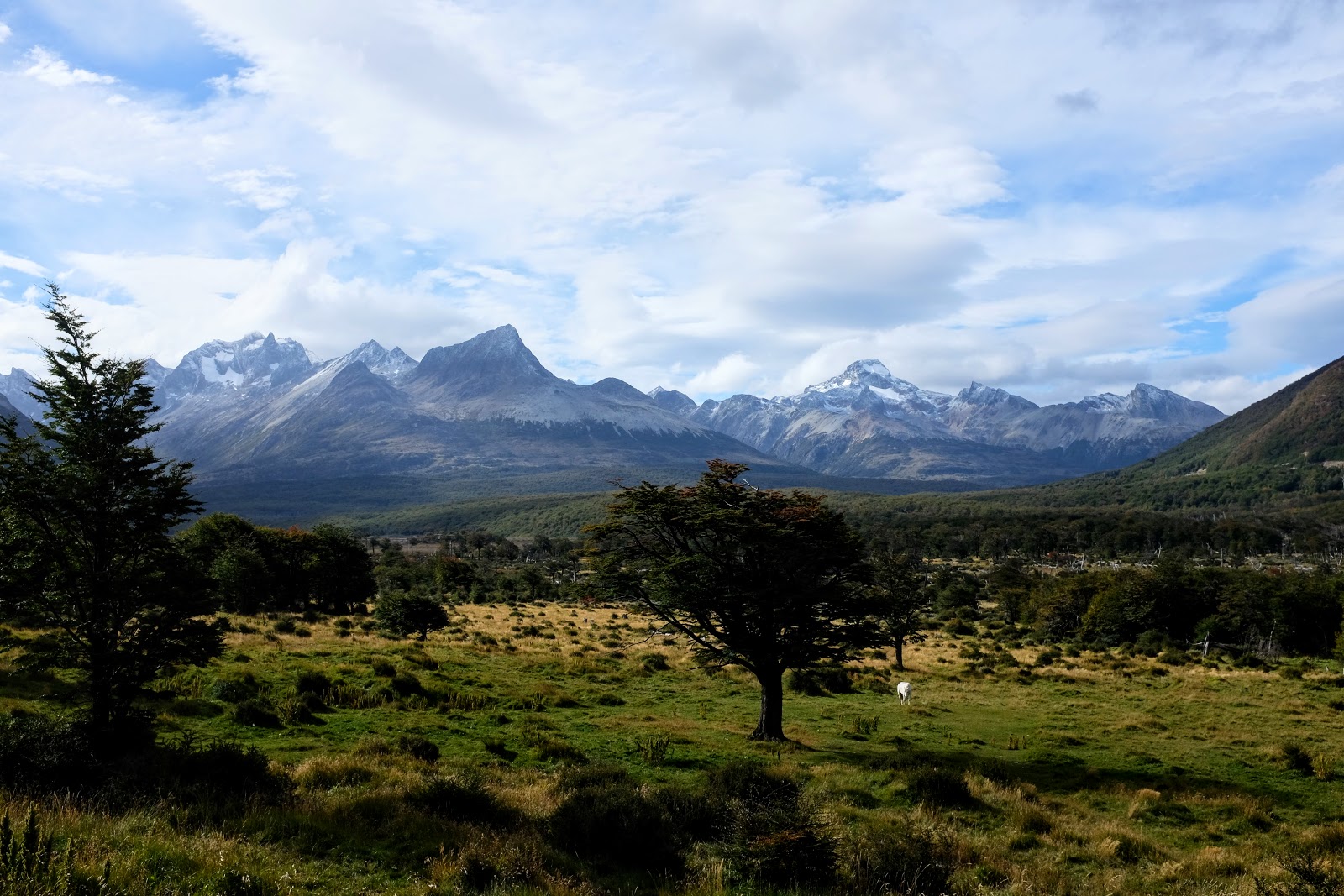
I was about to begin my first major hike through Patagonia: the Sierra Valdivieso Circuit. Without a hiking partner, I decided to register with the Argentine Civil Defense Force. The warnings and recommendations from the officers were digested, but there was a good weather window. I knew I had to take the opportunity. Prepared for a difficult hike in the mountain range north of Ushuaia, what was another few miles walking to the trailhead? The eight miles to the trail were as good as walking along a road could be. Whether in Ushuaia, on a road, or on a mountain, spectacular scenery was abundant. After sevenish miles, and before entering the mountains, I stopped for lunch. Lunch consisted of a can of tuna, cereal bar, and a spoonful of Nutella. Seated on a cliff overlooking a beaver dam on the Olivia River, a quick roadside lunch took on a new meaning. An interesting invasive species, Canadian beavers were introduced by fur traders to the area and have since wreaked havoc on the forests and rivers. With no natural predators, signs were everywhere informing people of the cleanup efforts and danger of downed trees.

At the turnoff where the official hike began, it was immediately apparent the area wasn’t well visited. I hopped two barbed wire fences, and a dog ran viciously towards me barking from a nearby farm. Hesitant, with my hiking pole in hand, a balding, stout, old man wearing a ripped jacket came yelling profanities at the dog. He apologized for the “old moody dog” and introduced himself as McDougal. I couldn’t have been farther from expecting a Spanish speaking farmer of Irish decent. He was very interested to talk with a “North American,” and cautioned me that there was no trail. It was beautiful but hard to find a way through the mountains. We finished pleasantries and as I began to walk, he left me with a laugh. His nine year old cow Mona had run away some time ago and he hadn’t found her. She was wearing a collar and if I came across her while hiking he requested that I please bring her back.
For the first half hour, the hike was easy along a narrow dirt road that locals obviously used often. I passed lakes, a single white horse, and downed trees everywhere from beavers. Soon, the trail disappeared, and I needed to cross a river according to a map I found before leaving. The swollen river did not look inviting. I decided to stay on the south shore and continued up the valley until an easier cross was available. Sharp bushes mixed with dense and downed trees made for a tenuous trek. I reapproached the river knowing I needed to cross. When I stepped through a series of logs, one broke sending me tumbling. Hitting my face on a neighboring stump, the blood and pain that ensued were familiar. Having broken my nose several times, I knew right away. It had been awhile since I hurt myself, and after a brief check I decided it wasn’t serious enough to send me back to town. However, the blood was an unfriendly reminder that there could be Pumas in the mountains.

Over, under, around, backtrack. The trees were brutal. There still wasn’t a good river cross, and my direction of travel began to turn away from the river. In order to make progress on the hike, it was necessary to follow the river through a valley before ascending the first mountain pass. I hiked a while longer, until I decided that the forest would not rejoin the valley. I was about half a mile south of the river, and I began the walk straight north towards it. The first steps out of the trees revealed something I had never experienced. Only half a mile separated from the river was a half mile of peat bog and swamp. The brutal landscape was squishy, wet, and abundant with hidden holes, ponds, and shrubs of different heights. Time was moving quickly, but my progress to where I wanted to camp the first night was not.
Feet soaking and tired, I finally made it to the river. It had taken an hour to walk half a mile. Luckily, the river was a little less swollen where I met it. I decided to cross where beavers had made a partial dam, and I could see logs resting on the bottom. Compared to the shallow muck in the bog and marsh, the freezing river was heart stopping cold. As soon as I crossed, I put back on my socks, pants, and shoes as fast as possible. Back on track, the walk west through never ending bog continued. Out of nowhere, a magical sight appeared: a tree branch with a piece of white masking tape stuck into the ground. Someone had burrowed out a trail through the bog and marked it. I was on track! As exciting as it was finding a trail, it disappeared about an hour later. Without the comfort of trail markings, I climbed the side of the valley to get a break from the bog into forest. Breaking through downed trees was even harder so I climbed back down. The rest of the afternoon was spent navigating swamp and bog. By the time I reached a spot appropriate for camping near one of the many streams feeding the river, it was 7:30PM.


I was soaked, and the sun was setting. The tent went up faster than it had ever been assembled before, clothes were torn off, and I burrowed into my sleeping bag. I was way too tired to think about cooking. I ate a handful of nuts, turned on some light classical music to complement the sounds of nature, and read in my tent until the quickly descending sun was gone. Exhausted after a near 20 mile hiking day, I wasn’t going to catch a break that night. As soon as the sun set, the winds picked up, the temperature dropped, and a cold rain set in. In and out of sleep through the night, morning and the sun couldn’t come quick enough.
6:49AM: a time that will stick in my head for a long time. It was the time I was fully awake every day of hiking. No matter what. “Day two can’t be as hard as day one” were words that never should have entered my mind. Having only eaten a handful of peanuts the night before, I had a large oatmeal, Nutella, and peanut breakfast before hitting the “trail” again. Almost immediately after starting to walk, I fell again in a dense set of trees. Day two was going to be much like day one. Luckily there was a trail of “on again off again” branches marked with masking tape.
The entire landscape was soaked, and I was exuberant to come to a point where it looked like there was no more bog. Instead, I began hiking up a mountain through a muddy forest. A tree marked with masking tape! Every time I saw one it was elating. Up high on a mountainside, something didn’t seem right. I should have been walking up through a valley. Instead, I was fighting through boulders covered in shrubs and impenetrable forest. Fortunately, my phone’s GPS was working. I used a trail on an app called MAPS.ME to orientate and rejoin where I needed to get to. After hours struggling to make it two miles, using the phone helped me get back to a clearing up and out of the valley. Finally, I found walkable terrain.

During the ascent, I spent more time than I would have liked navigating with my phone. However, in addition to natural landmarks, there was another navigation tool that began surfacing regularly: cairns. A cairn is a pile of rocks set up to mark trails by previous hikers. The one caveat to cairns is that you have no idea which trail or direction they are marking. It was still comforting to see that humans had previously hiked where I was.
After walking up for over an hour, a large circular ridge came into view. The ridge was the edge of a deep blue lake surrounded by mountains on three sides and the steep drop off I had just climbed. It was an incredible sight and the first major landmark outside the valley I had navigated the day before. A spectacular, cool, sunny day, the wind screamed through the narrow ascent and over the mountains. Another lake presented a few hundred yards beyond the first. Under the shelter of a rock, I stopped for a brief lunch and photography break.


In terms of progress, the day was nowhere near finished. It had taken longer than expected to navigate and circumvent the terrain in the morning. Back to hiking up, the cairns and any semblance of trail disappeared. My feet were soaked and weighted down from the waterlogged ground. Approaching the first actual mountain pass and highest point of the day, I began to turn and was suddenly surrounded with countless mountain tops above. Each peak was separated with what could have been interpreted as a pass into another valley below. The ground up to the potential passes was 1000 vertical feet of scree and loose rock. Going up would use a ton of energy and entering the wrong valley could be disastrous for a number of reasons.The gravest being that it would be very easy to enter the wrong valley and end up lost.
Before continuing, I brought out every tool I had: phone, multiple maps, and a compass. The wind was strengthening beyond its current intimidating rate, and the afternoon sun had moved across the sky. It was time to go. Unstable rock slid under each step as I fought gravity. A bit higher, there were larger broken rocks which I used like a natural staircase. Winded and nervous my mind went straight to the horrible thought of not being able to find the right pass. Would I have to backtrack through the bog and forest that I battled through the day before? At least I knew how to backtrack. If I go into the wrong valley will I realize and be able to climb the mountain on the other side? That question was yet to be answered.
Zig zagging along scree searching for stable footing, it took close to 45 minutes to reach a pass between two peaks. Between the work of hauling the pack and the answer to my dreaded questions looming, my heart pounded. Beauty! Utter beauty was all I could see from the top. My nerves calmed, I took off the pack and just stared. A desolate rock terrain with mountains and a deep blue lake were the only things my eyes and mind could concentrate on. A cairn! There was a cairn on the steep rocky descent into the valley below. It was the correct valley!

Using a technique of sliding on loose rock, carefully stepping, and climbing I scaled down the backside of the mountain. The relief of being in the correct valley quickly dissipated. There were still miles to go and another pass to get over. Navigating didn’t get any easier. Being up high now meant dealing with cliffs that came out of nowhere and forced me to stop dead in my tracks. Turn left a bit, turn right a bit, back left, straight, look at supposed location on the phone; hours passed trying to find a path through. Every time I looked up from the phone and made sure I wouldn’t roll an ankle everything went still: the scenery was breathtaking.
Another pass! This one I was sure of. My watch hit 5:00PM. What I assumed would be an easy final descent to finish the day wasn’t easy. Ravaged by fire, the backside of the mountain into another valley was a scene of burnt mangled twisting trees, thick thorny brush and mud. A cycle of “slide, walk, fall, crack!, unsnag shirt, stop” was repeated for an hour and a half. Struggling like mad, I thought the valley floor would never come.


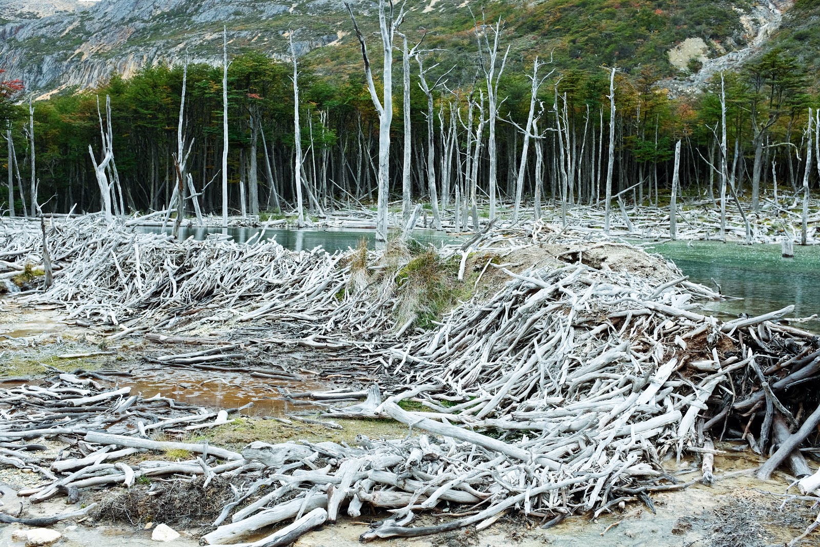
Sounds of a rushing river were within earshot before it’s blue waters came into view. Beaver destruction dominated the landscape where fire hadn’t reached. An hour up river was a waterfall I had marked on my map as the evening’s campsite. It was 7:30PM again by the time I arrived. Next to a bright fall colored orange shrub, under the waterfall, and steps away from the river for fresh water, the site was worth the day’s pain. With plenty of food remaining, I needed to eat weight out of my pack. On the menu tonight was quinoa with curry, onion, ginger, and peanuts. Instead of classic music, I put on the sounds of a campfire. No fires were allowed in the area for safety. The wind was brutal that evening, but the artificial sound of fire and the natural waterfall made for an idyllic chorus.

Winds held their intensity well into the morning. Day break would not be a source of solace after a rough night. Savoring the warmth in my sleeping bag before beginning the day, it was hard to get moving. I cooked breakfast inside the shelter of the tent to replenish the dwindling calories in my system. According to the map, the day would be shorter than the previous two. About eight miles in distance, and over one 2000 vertical foot mountain pass, there was a free refuge named Refugio Bonnett where I could spend my last night. As I should have expected, the day was not going to be a simple walk in the park
The largest beaver dams I had seen were just steps away in the wet swampy mix on the valley floor. From what I could predict, the 2000 vertical feet I had to get up were going to be gradual until just before the pass where there would be a sharp climb. Soon after beginning the trek, it was not a surprise when I began ascending a hillside through a forest. Continuing my graceful routine of falling over trees while using the phone to try and avoid dead ends proved to be more complicated than following instinct. Breaking through twisted unstable trees was getting very old. I put the phone away and weaved up and back across a shallow river. Around a bend towards large mountains in the distance, high up on foothills, the valley below was beautiful.
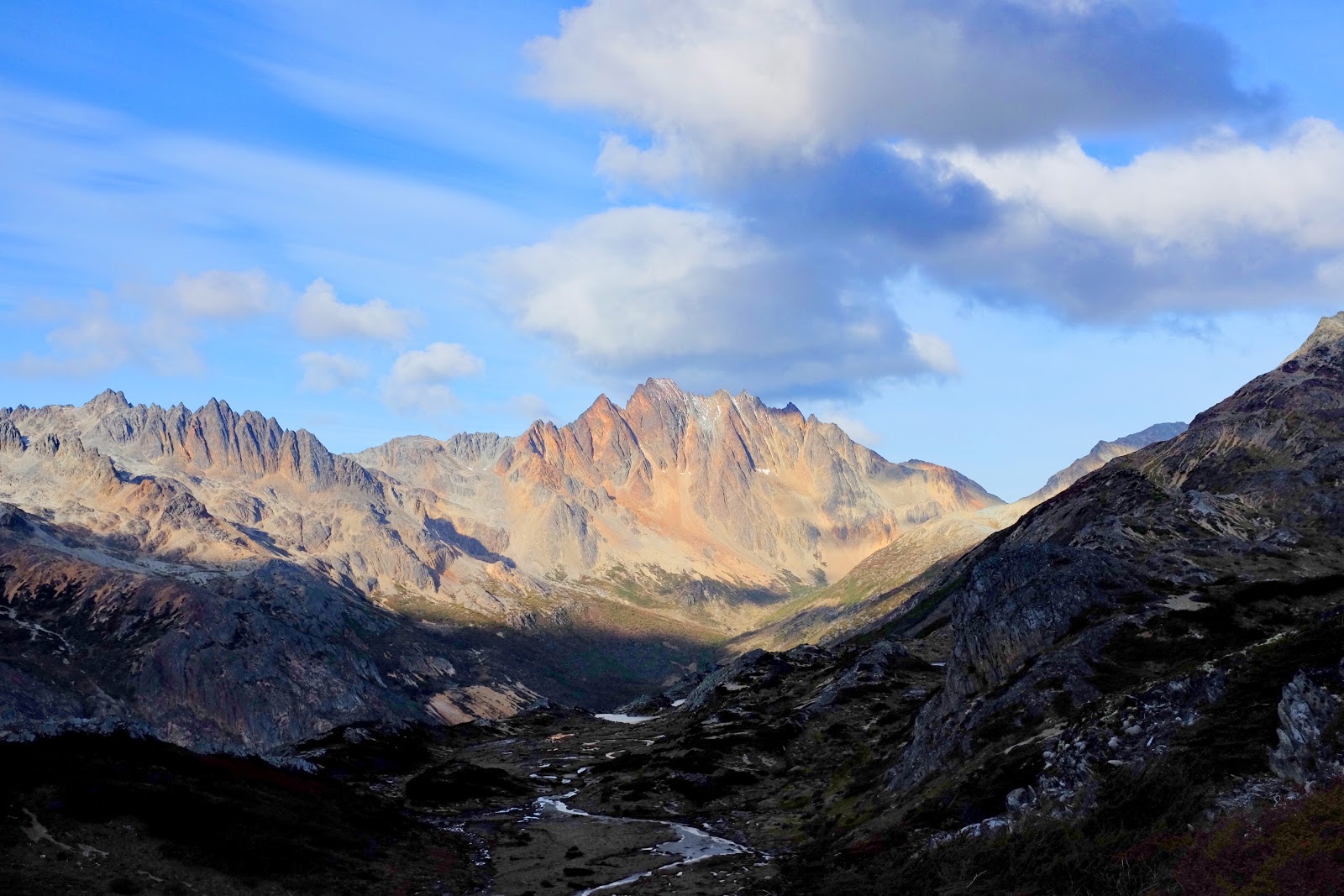
The pass was near. Orange scree and boulders replaced mushy bog, and another river ran down from above. Rushing water bleached the color from the rock leaving them white. It created an optical effect of a white river in a sea of burnt orange. My prediction of a steep final ascent was right on. The comfort of cairns built by other hikers were leading up and up and up. As I passed the last Cairn, I realized I hadn’t seen any people or spoken in almost three days. “Thank you for building the cairns, and thank you for giving me a tail wind up the climb.” That was it: my only words for days.


At the pass, wind ripped forward stronger than ever. There were mountains as far as the eye could see. Dead ahead was a valley with a lake, and I began the slide down. About halfway to the bottom, something didn’t seem right. Pausing, I took a seat on a boulder and decided to make sure the valley was the right one. Wouldn’t it be something if I went into the wrong valley now after successfully navigating the last few days? Maps, compass, and phone were back out. The valley below continued straight south, and I should have been going east. Up and behind me I noticed a traverse and additional ascent between two peaks headed east. There was only one way be sure if I was right or not: I began the climb back up. Panting and fighting the sliding rock, I reached the pass neighboring the one I had come through earlier. Had I traversed instead of descended, it would have been an easy cross. Instead, I was running on fumes. At the start of the pass a cairn appeared. A close call again, but I was confident I was back on track.


A sliding descent down scree was dangerous with hidden boulders and cliffs. Slowly making my way down, I thought I was in the clear. Around three and a half miles to go through flat valley. I was wrong again: the adventure continued up and down, up and down, through mud, fighting through beautiful fall colored shrubs that grabbed my feet and made me fall, and finally through a swamp and bog maze made from beavers damming rivers and chopping trees. With the worst weather I had faced so far, it seemed like the refuge would never come. Up ahead I saw something odd and man made. It was much more substantial than a cairn: it looked like an ATV course dug through the bog. I followed it. I was almost there!


A pointed roof and chimney atop a small log cabin were the best gifts I could imagine. Soaking wet from rain and drudging through swamp, I shouted “helloooooo!” when approaching. There was no answer. Inside the cabin was an axe, wood fire burning stove and donations left by previous occupants. The walls were covered in messages written directly onto the wood and small pieces of paper nailed up. It would have been nice to have company, but being indoors with a fire was paradise regardless. I immediately went outside, collected the driest kindling I could find, found larger dead wood and began chopping away with the axe.
The fire burned strong inside the black iron stove. I put my sleeping bag as close as possible to the source of heat, and cooked dinner to the sounds of crackling fire, rain pounding on the roof and wind whistling through the cracks between logs. After dinner, I made a pot of ginger tea and laid down: safe, relaxed, and dry. With no one to talk to, I longed for someone to share this place with. At that moment, I decided that from then on, I would find hiking partners for hikes longer than three days. While writing, I slowly drifted off to sleep.
The fire burned strong inside the black iron stove. I put my sleeping bag as close as possible to the source of heat, and cooked dinner to the sounds of crackling fire, rain pounding on the roof and wind whistling through the cracks between logs. After dinner, I made a pot of ginger tea and laid down: safe, relaxed, and dry. With no one to talk to, I longed for someone to share this place with. At that moment, I decided that from then on, I would find hiking partners for hikes longer than three days. While writing, I slowly drifted off to sleep.


Freezing feet and a shaking floor pulled me from sleep. It was pitch black. The wind outside ripped wildly and roared when it snuck through cracks in the logs bringing an icy chill. My fire had died out, but thankfully I was inside. It was 2:00AM and brutal outside. I wouldn’t go back to sleep that night and waited for the happiness brought by morning light. A fresh snow blanketed the mountains above. The rain soaked ground had frozen into a crunchy sheet of ice. Before leaving I wrote in the visitors book and on the wall, “La Aventura de Mitch Sierra Valdivieso 2017.” I was ready for this hike to be over.
I began walking and found my way, but as usual the “path” was unclear and I climbed and descended the mountain. After walking about an hour and a half, off in the distance I saw people! The first people I had seen in four days. I was about 600 feet above where they were on the other side of a valley. Happy to see them, I climbed down at an angle and must have looked like a bear. My last stop of the trek was to a popular emerald lagoon named Laguna Esmeralda. A popular day hike, the ground leading up to the elevated lagoon was worn away with footprints. Tourists carefully stepped and screamed as they sank into mud. Me, I was like an animal after being out for four days and happily marched straight through. Up over a ridge, the Laguna was better than I expected: there were mountains at the back, a river flowing out at the front, and the bluest of blue water.


After taking photos and talking to every person that got close enough for a hola, I marched the final six miles out of the range. It was the muddiest part I had been through, but there was a well marked trail. Walking along a trail was such a different experience than the previous three days: it was like a superhighway out. My mind was calm, and I zoned out walking straight without thinking. Back out at the main road, Highway 3, north of where I entered the trek four days prior, I put down my pack and threw up my thumb.
In ten minutes, an enthusiastic young man who worked in the National Park pulled over and picked me up. He took a look at me and asked, “Are you hungry? Want a banana?” Laughing, I yelled “please” with excitement. Broken swollen nose and covered in four days of mountain sweat and swamp water, this guy earned the award for the bravest Ushuaian. We laughed and discussed my adventure on the way back to town. Before going back to the hostel, I had a few errands to run: I stopped by the Civil Defense Department to let them know I was back and then went to the supermarket. I walked another two miles back to La Posta hostel and ate a kilo of meat, a potato with onion, and drank a bottle of wine for dinner. It was a meal fit for a king.
My time on the bottom of the world was running out. It had been eleven days since I landed in Puerto Natales, and I needed to make my way back to begin the W-Circuit in Torres Del Paine. On the walk out of town, three woman in a hatchback pulled over and picked me up. They asked if I was an actor when I told them I lived in California to which I replied of course. We had a lot of laughs as we listened to Nicky Jams and zoomed back along the winding roads I had come in on what seemed like months prior. The women drove me two hours back to Rio Grande and dropped me on the far side of town around 2:30PM. After a hug goodbye, I walked past a couple trying to hitch who had been outside all day. I knew I was in trouble, but walked down the road to give them space and waited. The wind howled, the couple was picked up, a rain started, and traffic slowed to nothing. I just stood there with an empty road on either side of me. I enthusiastically stuck my thumb out at every car that did pass, but no one stopped.
For two hours I stood out there until a white work style van pulled over. The guy said he was going to Punta Arenas, at least an eight hour ride, and I couldn’t have been happier. I threw my stuff in and we hit the road. The man’s name was Gustavo, and he was one of the coolest people I had met on my trip! He was about forty, dressed in climbing clothes and lived in Ushuaia. He was an ice climber and mountaineer who had been all over Patagonia. The two of us shared stories and photos and drove through Tierra Del Fuego on the long open desolate roads. Strong winds pushed the car from side to side. We made it to border control, got out and a group of guys greeted Gustavo and me. It was like they were all brothers. Gustavo told me they did some climbing outside Ushuaia and in El Chalten together. These guys were awesome!
After customs, we drove north east for hours. At one point Gustavo said he was tired and we pulled over. We stood outside the car while I made coffee in my moka pot. As the sun went down and the moon came up we put movie soundtracks on the radio, sipped coffee, and made our way to the ferry crossing the Strait of Magellan. There I was; with an ice climber speaking Spanish and listening to Braveheart in Tierra del Fuego. It was another one of those real life movie experiences. I get goosebumps thinking about it. We made it to the ferry around 8:00PM, and there was a huge line! We were going back a different route than I had taken on the way in to Tierra del Fuego. We were crossing the Strait on the north side of the island.

Gustavo turned off the car and we sat and waited about 1.5 hours in the cold to get on a boat across the choppy sea. Water splashed the windshield as the boat rocked side to side and after a quick 40 minutes, we were on the mainland. It took another hour and forty five minutes to drive to Punta Arenas.
After calling Endless Sky Hostel, the hostel I previously stayed at in Punta Arenas, we finished the drive back South along dark empty roads. The owner greeted me as an old friend and we all passed out.
The next morning we were up early. Gustavo and I shmyed around town looking at climbing gear. I was sad to leave my new friend, but he was off on a different adventure. He was taking a ship to a city named Puerto Williams, and I wanted to get to Puerto Natales. He gave me a ride to the far side of town, we exchanged numbers and a hug, and a pact to do a climb together in the future. I’m sure I will make it happen.
After another successful hitch and another new friend, I was back on the side of the road. I was now heading north. Thumb out, backpack on, Torres Del Paine was waiting.


Comments
Post a Comment